
Kettle Falls Archeological Inventory
By Andrew LaBounty, National Park Service
For the past four years, Voyageurs National Park has been developing an archeological inventory of the Kettle Falls area. The project began with a review of what we know, and from there the project was designed to target missing information. For example: there are hundreds of historic photographs of the Kettle Falls area, but it is often a mystery exactly what they show, where the photographer was standing, and when the shot was taken. Through careful review of the historical record and a little bit of careful excavation, we learned a number of things about Kettle Falls in the past few years – and generated a lot more questions.
One of park staff’s main goals for the archeological inventory was to pin down the location of historic buildings that are no longer standing. There are many examples of historic structures at Kettle Falls, but Chris Monson’s trading post is one of the most iconic.
Chris Monson was the first damtender who lived in the old log cabin that stands toward the west end of the National Park Service (NPS) marina on Namakan Lake at Kettle Falls. At some point after 1910, he built and operated a trading post on the Namakan side of Kettle Falls. There are many photos and oral histories, but little evidence of when or where his store was located.
The archeological inventory combined four kinds of data: 1) ground penetrating radar, 2) archeological excavation, 3) historical photo analysis, and 4) oral histories. Using all four of these, park staff were able to put Chris Monson’s trading post on the map with confidence, and to assign it some tentative dates of operation within the greater history of Kettle Falls.
Chris Monson’s Trading Post and the Timeline of Archeological Research
2014
Park staff knew the general location of Chris Monson’s trading post through oral histories and previous archeological research. For example: in 1991 Reuben Christenson related to a Voyageurs National Park (VNP) historian that:
“Chris was a very likeable guy, wore glasses. He lived in the building where he operated his store. It was located near the lake shore in front of where the company house [the white building] is now on the Namakan side. It was still there in 1938.” –Reuben Christenson, 1991
This provided a starting point for recording the physical location of the building and determining what—if anything—was left.

Blue/purple shading shows the compacted detected by ground penetrating radar in 2015. Two different areas look like they may have been related to buildings.
2015
In hopes of putting Chris Monson’s trading post on a map, park staff operated ground penetrating radar over the lawn of the existing company house in 2015. The results were inconclusive, and did not identify a foundation. Instead, a few highly compacted areas of soil were revealed, which park staff believed indicated where a large building sat directly on the ground surface.
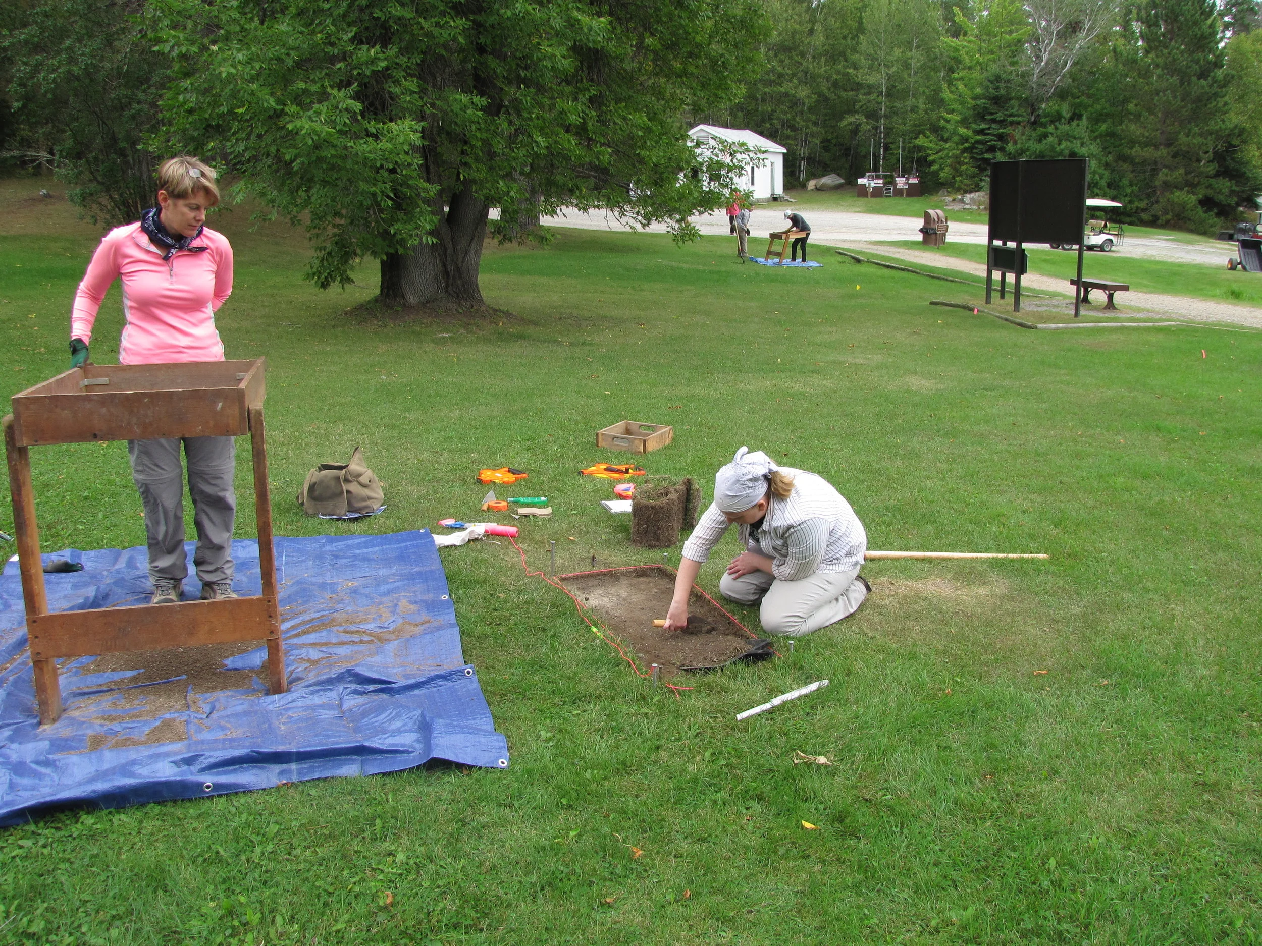
NPS Archeologists from Lincoln, Nebraska carefully excavate layers of soil in 2016 to recover any preserved information related to Chris Monson’s trading post. One Test Unit is in the foreground; a second Test Unit can be seen in the background.
2016
After using ground penetrating radar to select excavation locations, few artifacts were revealed indicating a building ever existed. One small area east of the supposed structure revealed rusted nails and tarpaper tacks that suggest the location of Chris Monson’s Trading post.
2017
All of the evidence gathered so far was brought into a geographic information system (GIS) using precision Global Positioning System (GPS) and field measurements. This allowed park staff to overlay historic maps with the compacted soil, the meager collection of structural artifacts, and any existing landscape features (such as the company house mentioned by Reuben Christenson). Through these overlays, the International Boundary Commission survey was found to be the earliest map with a corresponding building at the correct location. The map dates to 1913 or 1914, just about exactly when the Kettle Falls hotel was built, which happens to be a logical construction date for a trading post as well.
2018
Using historic photos and the known location of another trading post to the east, park staff were able to confirm the identity of Chris Monson’s trading post. This “unlocked” several new visual cues and dates. When looking through historic photographs related to Kettle Falls, just one photo shows all three structures in sequence—the 1910 damtender’s cabin on the left, Monson’s store in the center, and the second trading post to the right. The same buildings could then be identified by their style from different angles in other historic photos, generating a visual record and additional dates, helping to build the timeline of all three structures.
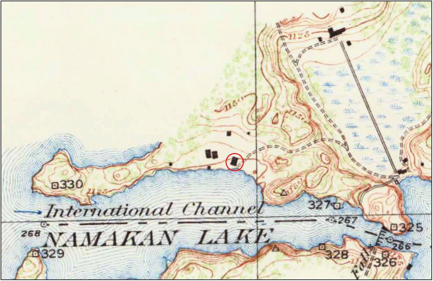
International Boundary Commission survey map, sheet 14. Survey data was collected in 1913 and 1914, and then published in 1928 (Source: VNP Collection). Circled in red: the most likely location of Chris Monson’s trading post according to archeological survey results. What are the other large structures at the Namakan landing? Why doesn’t Jack Ryan’s trading post appear here?
Continuing Research
It is still not exactly clear when Chris Monson’s trading post was closed and removed. Reuben Christenson relates that it happened sometime after 1938, and the store was probably gone by the time the company house was built in 1945 (the white cabin you see when you disembark at the Namakan landing today). What is clear, however, is that Chris Monson’s store was a prominent landmark in the history of the Kettle Falls area. We now know precisely where this building was located, we know its size and orientation, and we recognize evidence of the structure in a layer of compacted soil. Based on soil profiles in the immediate area, we also believe that part of Chris Monson’s trading post may have been impacted by flooding and erosion, with a section of the building now lost to the lake. Perhaps it was the dynamic shoreline and the water levels behind the dam that ultimately prompted the veteran damtender to move into his new house in 1945 (which is high and dry, comfortably upslope behind the old trading post).
Archeological research continues in 2018 to further develop this and other stories throughout the Kettle Falls area. Park staff are currently working on a full report of the archeological inventory, which will help guide park planning and lead to greater interpretation on-site and in park records. As each question is answered, however, more questions are raised. What are the other two large structures depicted on the International Boundary Commission map west of Monson’s store? When was Jack Ryan’s trading post established, and why doesn’t it also appear on the map? Archeological research is often iterative, and as one research project raises questions, the next research project will build toward new answers.

1910 Log Cabin (center-left), Chris Monson’s trading post (center-right), and Jack Ryan’s trading post (far right). Photo taken toward the northeast from Namakan Lake between 1913 and 1930, when Jack Ryan’s trading post burns down (Source: VNP Collection).