
By Drew LaBounty, Voyageurs National Park Many who have visited Kettle Falls will remember the familiar sights of the dam tender’s cabin, the company house, trading post, hotel, and the dam itself – all bustling with activity in the wilderness of Voyageurs National Park. Many others know the complex and colorful history of this place, and some lucky few have lived it personally. But there are even older stories at Kettle Falls, stories that have been buried over time and passed completely out of memory.
Starting in the fall of 2015, Voyageurs National Park began an archeological inventory of Kettle Falls. In contrast to other kinds of inventories, archeologists document information about the past using evidence buried in the ground. The study will resume this fall, 2016, and is intended to add a new dimension to what we know about this place.
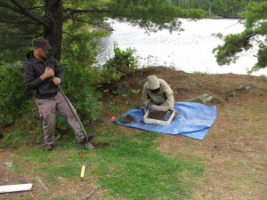
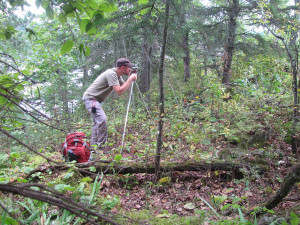
Last year, VNP worked with the NPS’ Midwest Archeological Center in Lincoln, NE to run geophysical instruments across the front yard of the company house at the Namakan landing. These tools measure the soils’ magnetic fields (magnetometry), their ability to conduct electricity (conductivity), their ability to resist electricity (resistance), and the soils’ permeability to radio waves (ground penetrating radar). Each of these instruments records something about the soils and what objects may lie underground. Magnetometry, for example, is so sensitive that it can detect the stronger magnetic field of soil or rocks that have been burned by a campfire. Conductivity meters, like those used in the construction industry, can locate the metal in buried utility lines – or the metal of a small machined nail used to hold an historic structure together. One of the best known instruments, ground penetrating radar, identifies shifts from looser to denser soils, and can reveal the packed earth resulting from a structure.
In addition to all these geophysical instruments, small-scale archeological excavations were placed along the shorelines above and below the dam. By slowly digging smaller holes and carefully examining the soils for artifacts, archeologists hope to piece together the past environment and people’s activities before recorded history.
Early findings from Year 1 will guide further archeological work this fall. Last year, the geophysical instruments revealed shapes and corners at the Namakan landing that suggest the location of the original Monson’s trading post. These so-called “geophysical anomalies” will be carefully uncovered to learn whether they represent a building, how and when it was built, and ultimately what happened to it. The remaining evidence will then be preserved underground and interpreted with photos, maps, and historical accounts. Meanwhile, dirt-and-shovel investigations along the shore suggest a history of small fires previously unknown at Kettle Falls, and in other places, there is evidence of a Native presence whose activities may be among the first at Kettle Falls. Each of these clues reveals a deeper history of the land that will be teased out in Year 2.
If you visit in the fall, you may see crews out digging in the lawn at the Namakan landing and carefully sifting through the soils, mapping foundation ruins in the woods, and matching up historic photos to the modern landscape. All of these activities (and more!) will add even greater time-depth to the rich and colorful history that has always fascinated visitors and residents alike at Kettle Falls.

